> > > > > > > > OHV MARKED COURSES
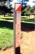
 Here's a list of marked orienteering courses looked after by Orienteering Hutt Valley and our sister club Orienteering Wellington. They consist of the map, some instructions which may be on the map or separate such as with a camp warden, and permanent markers at the control sites. These may be specially inscribed posts, or plaques fixed to a fence or building or other distinctive landmark. The best (most recent) files are at the top. If you are interested in an area not on this list please look in Virtual courses or contact Here's a list of marked orienteering courses looked after by Orienteering Hutt Valley and our sister club Orienteering Wellington. They consist of the map, some instructions which may be on the map or separate such as with a camp warden, and permanent markers at the control sites. These may be specially inscribed posts, or plaques fixed to a fence or building or other distinctive landmark. The best (most recent) files are at the top. If you are interested in an area not on this list please look in Virtual courses or contact
Feedback! We want to know if you like these courses! Email the name of your group (eg "Smith family"), the number of people in it, and which course you did and when, to
Use "Anytime Orienteering" as the subject, and add your comments. We'll try and reply with a suggestion about the next club event we think would be good for you.
This page was first assembled by
and was last updated on
3 May 20.
By downloading you accept the following conditions:
- Copyright
These maps remain the property of the orienteering club which created them. They may not be modified, reproduced or copied in any form without the explicit permission of the club. BUT clubs hereby give permission for download and printing without change by individuals for personal use and teachers for use by schools.
- Accuracy
We are proud of our orienteering maps but make no claim that any of the maps are free of error or fit for any particular purpose. By using the map, the user releases the orienteering club from all liability for errors, omissions and other inaccuracies.
- Print Quality
Orienteering cartography is optimised for printing at a commercial service with the latest equipment. The result will not be as good when printed on the typical home printer.
- Use of Map
Possession of an orienteering map implies and confers no right of access for orienteering or any other purpose, whether on a road, track or elsewhere. You must seek out the landowners and obtain permission.
- Safety
You take responsibility for your safety and obligations to others. Enjoy!
© Orienteering Hutt Valley
- Waikanae Park, Park Avenue, Waikanae. Public reserve with gardens, bush, paths, open areas. Adjacent swimming pool. There are 24 control points consisting of wooden posts with a small orange/white plate, and the instructions suggest three different courses you can do. Maps which include the instructions are available from Kapiti Coast Service Centres or download it here.
- Mt Victoria, Wellington. Steep town belt with passable forest and numerous paths. Public reserve handy to downtown Wellington. There are 30 control points consisting of an orange/white plaque fixed to a feature such as a post, and the instructions suggest four different courses you can do, starting from the top of Majoribanks St. Download the map and instructions from the Orienteering Wellington website.
- Wellington Waterfront. Wharves, parks, pubs, cafes, museums, art galleries, playgrounds, etc. 21 control points between the railway station and Te Papa, consisting of a black-and-white plaque. Designed to be done in order from the start at Queens Wharf (near the sail), record the letters to discover the hidden sentence. Allow 30 minutes. Download the map and instructions from the Orienteering Wellington website.
- Brookfield Scout Camp, Moores Valley, Wainuiomata. Accommodation buildings and campsites in a bushclad setting, with numerous tracks. Area 0.5sq.km. 26 permanent control markers consisting of wooden posts, and the warden holds a kit of laminated maps with all the points marked. There's also an instructor's guide suggesting various combinations of the controls for beginners, second-timers, etc.
Alternatively you can download the map and print yourself a copy. The area is not public property; permission for use should be sought from the warden, Ph 04 564 1000.
- Other Parts of New Zealand. There's a list of permanent courses elsewhere in the country here. No details unfortunately but you can use the club directory to get further information.
|
 OHV MAPS