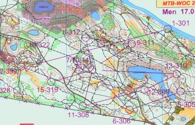
Michael (who wasn't there): A piece of the Middle Distance map is below; the scale was 1:10,000. Note the complexity of the route choice to #1, although I would guess there are some mental short-cuts. Working back from the control there are a limited number of ways to cross the green downslope near the control. And the landscape is characterised by holes with or without water in them - which define obstacles to avoid.
Note also the intense use of a small area with "butterflies" or "clover-leaves". You arrive at a control, the next couple of controls takes you in a loop and back to the same control, then you do a second loop before heading off to a new part of the map. See control 7/10/14. Trevor Knowles set a course like this at Waitarere in 2004.

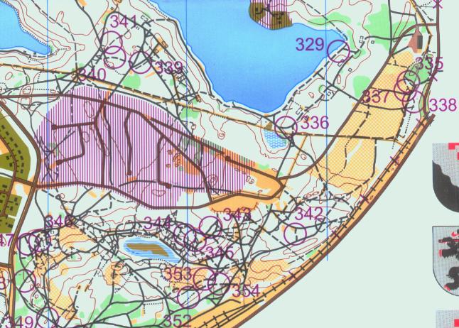
Marquita: The circle you mention 335 is exactly where I had problems in the relay - I couldn't tell which track it was going to be on, especially when trying to decipher it while bouncing along on the bike. I lost 1.5 mins or so, more than I should have I guess but I was rather rattled due to the uncertainty and got rather confused once I was there. The other two controls in that area were very very close too, you could see one from the other and could see other riders going to them so that made it worse.

Dianne: My DSQ was due to punching one of the mens controls during the long distance qualifying race. This pinged me to the B Final where I completed the course to find later the Emit (brand of electronic punching used) card had not recorded any info from the controls so I was therefore credited with another DNF. Rob had the card checked and the info was finally recovered via back up, where my ride had me in first place in the B Final. The official website has not been updated. Generally the courses were well set, particularly the middle distance. The track network was very dense and technical.
Michael: The grapevine says that Emit will not be allowed for MTBO in future. It uses a plate the size of a matchbox which has to be put the right way round onto the top of the control post. The competing system, SI, has a stick which just has to go into a hole, any way round.
Michael: I see the purple cross-hatch was used - was there any misinterpretation of it as there was at Naseby? I.e. people thinking they could use roads/tracks inside the hatched area? I see purple crosses were also used and they are clear enough except where the road is at 45 deg to N-S when one of the bars is hidden by the road and the other can be taken for an obstacle symbol.
Marquita: The purple cross hatch was not popular and this was the cause of the DSQs in the mens long qualification. They had 2 maps in this race - on one the cross hatching extended way over the road (as it did on the womens map), and it was easy to see that the road was out of bounds. On the other map, and on the relay map, the hatching did not extend far enough and riders simply didn't notice it. Personally I think the X's over the road are better, although I guess if a whole area of tracks is off limits that would be rather messy. They just need to ensure that the hatching extends a good 5mm or more over the road. It is much harder to see when actually riding, compared to sitting in a chair.