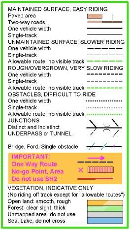
 The map used at Tunnel Gully today (Wgtn MTBO series #2) used a 4-level track-speed
system instead of the previous 3. Here is the reason for the experiment - your comments
are invited.
There is an international specification for MTBO maps. It provides for a 3-level track-speed system, known as "3x2" because there are two track widths represented as well. I've always felt that the middle speed had to represent too wide a range. But I thought that different dash lengths wouldn't be able to be distinguished on the ride.
The Australians have introduced a 4x2 system, and the feedback is favourable. I decided to try it at Tunnel Gully. It still has solid lines for what we call "maintained" tracks - actually the specification talks about "with a stabilised surface", which would be seal or gravel. It still has tracks that look like dots for barely able to ride, at best. But in between there are long dashes and short dashes.
The long dashes are for tracks that don't have a stabilised surface but are still smooth enough so that speed is reduced only a bit. At least in the dry - when it's wet they would slow down a lot more. A good example is the track on the ridge immediately above the tunnel. On a dry day this is pretty fast, although today the heavy dew may have made it a bit sticky.
The short dashes are for tracks that slow you down a lot, but there is no question that in good weather you're still on your bike. The slowing could be caused by ruts, roots, hoofmarks, long grass, vegetation crowding in from the sides, lots of reasons. Not the slope though, this is represented by the contours. You have to imagine the track as if it was level. In wet conditions these tracks might degenerate to the point where you can't ride continuously. An example of this category is the "Goat Track" between controls with codes 221 and 218. The speed reduction here is caused by both the periodic watercourse crossings and the current vegetation. But I think it's ridable except for one gnarly stream crossing. And I guess that stream could be marked by a purple bar for a specific obstacle.
I'm sure the distinction is worth making as this information is needed for fair route choice. The question is whether long and short dashes can be distinguished on the ride. Study your Tunnel Gully maps and see whether the info would have affected what you did. if you have views either way. We'll continue the experiment for a few events yet.