Past results: 2017
Orienteering in

Exp-O
the Hutt Valley
Hutt Valley Orienteers present...
Experiments in Orienteering
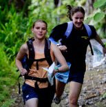
For the first 30 or so years of orienteering in New Zealand, there was one type of orienteering. It took place in the country (preferably a forest) and lasted an hour or so for experienced and fit people, maybe down to half an hour for kids. There were a few "mountain marathons" in which hardy types orienteered over a couple of days using topo maps, but these were exceptions.
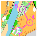
Then there was an explosion. City parks, hitherto regarded as suitable only for beginners, were recognised as interesting for short, fast-paced, visible orienteering. That led to maze-like urban areas. Skiers and MTBers discovered places where there was lots of route choice - on tracks the high speeds made navigation really challenging. And the MMers, by now using the rogaine score-event model, expanded downwards to a few hours, running them on foot, in kayaks, on buses, on horseback, during the day, and in the dark.
Meanwhile, the "classic" orienteering map at 1:15,000 was under increasing pressure as clubs found areas with complex detail such as sand dunes, rocks, dolines and 19-century gold diggings. And people are flocking to them! Even masters and veterans with fading eyesight - so we're using larger scales so that everyone can enjoy.
OHV has had a significant role in this, pioneering rogaining and MTBO in New Zealand, and playing a huge part in sprint orienteering with its O-Max formula. Exp-O is a label for more experimental events. We will find other challenging terrain types and invent further competition variations - nothing surer.
Read more about particular Exp-O formulas. They won't all succeed, but we'll have fun trying!
We question the mode of transport...
|
|
ORIENTEERING ON FOOT: "involves finding your way through unfamiliar terrain using a map." Competitions are usually individual, but groups are welcome too. Checkpoints may have to be visited in a certain order, or a time limit is set. Courses can take anything from 10 minutes up, with an hour quite common.
Learn more... |
ROGAINING: "a sport of long distance cross-country navigation", in which teams of two to five people visit as many checkpoints as they wish in a set time period. "Long" is anything up to 24hrs, but the skills can be practised over any period, such as one hour.
Learn more... |